
Giraffe is your deal-making assistant for multifamily housing
With Giraffe as your feasibility assistant, real estate developers find sites, confirm viability, model yields, and prep for the investment committee—all in one coordinated, AI-enhanced workflow.
What customers say
"I use Giraffe every day at this point as part of my toolbox. It shows me downtown Oakland when I open it and makes me smile before I start work."
Jason Ambrose
Director, Neatline Creative
"Giraffe has been a total game-changer for us. I use it from the moment I find a piece of land — zoning, wetlands, elevations all in one place. What used to take a few weeks of back-and-forth with brokers and consultants now takes a few hours."
Jack Ross
Director, Investments - Summit Real Estate Group
"We were able to easily integrate the Giraffe technology into our current deal flow systems, which saved valuable time for all of our teams."
Dusti Wofford
Global Head of Digital & Technology Strategy, Trammell Crow Company
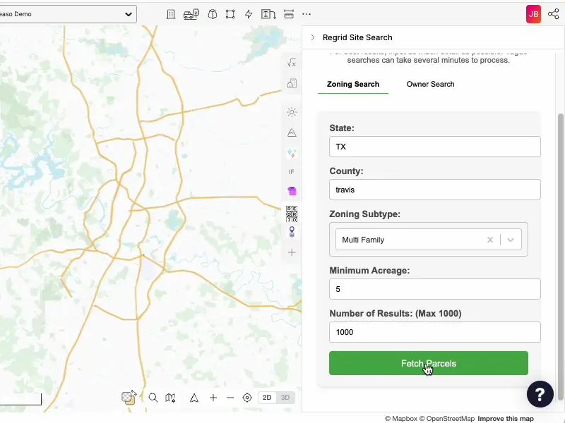
Finding potential housing sites shouldn't require squinting at a map or relying on broker reports. The Giraffe Parcel Finder quickly checks markets, zoning, and ownership status to zoom in on sites aligned to your investment thesis. Integrated with comprehensive parcel data from Regrid, it helps you focus only on the sites worth a second-look.
Find the viable sites
Finding potential housing sites shouldn't require squinting at a map or relying on broker reports. The Giraffe Parcel Finder quickly checks markets, zoning, and ownership status to zoom in on sites aligned to your investment thesis. Integrated with comprehensive parcel data from Regrid, it helps you focus only on the sites worth a second-look.
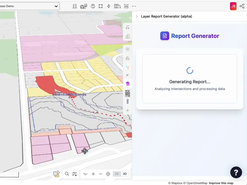
Identify site constraints early
Run initial due diligence from your desktop with the Giraffe Site Checker. Review setbacks, easements, hazards, and zoning conflicts before you spend on consultants, and build reports that identify the red flags fast.
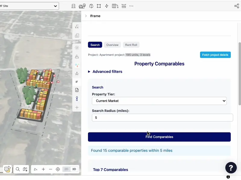
Build accurate revenue models
The Revenue Forecaster pulls comps and rent rolls with HelloData.ai, helping you benchmark your investment thesis. Match unit mix to real-time rent rolls, run sensitivity models, and project time to stabilization and IRR.
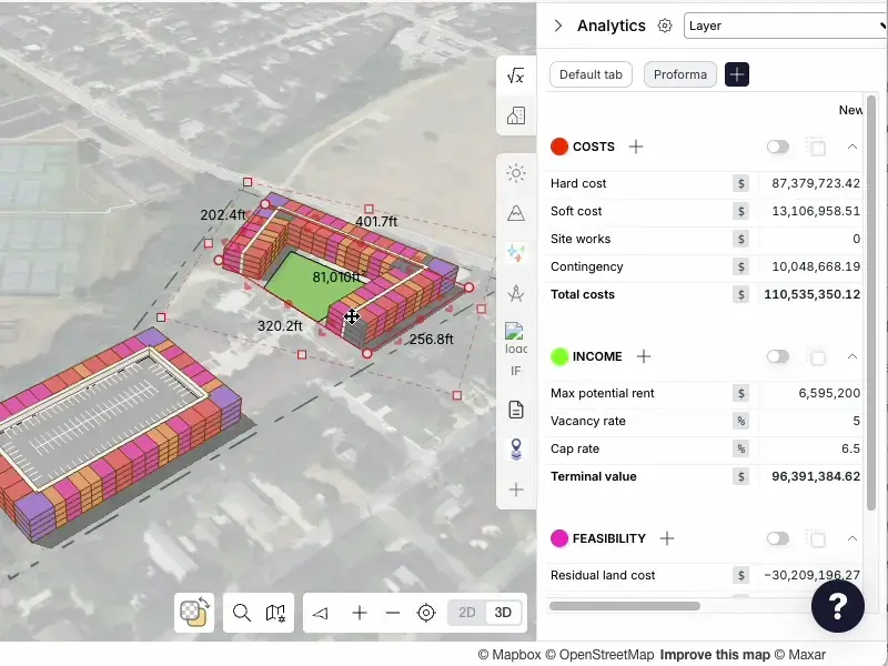
Generate site plans in minutes
The Site Planner codifies your product standards (wraps, podiums, towers) and produces a kit of parts, helping you accurately layout a site in minutes. Connect your plans to revenue and cost models—streamlining feasibility from the start.
Giraffe is a tool, and a platform.
Giraffe is designed as a layered platform. Some teams start simple, others run their complex business processes on it. You can adopt Giraffe at the level that fits your business today, and grow into more over time.
Platform
Your core real estate operating system
A secure, globally-scaled platform for working with spatial data, workflows, and AI.
Built for developers, planners, designers, and analysts who want to move fast:
- Connect data layers and geometry
- Build and run apps and workflows
- Automate analysis and decisions
No credit card required. Start immediately.
Configured Data & Apps
Ready-to-use intelligence for real estate workflows
For teams that want value on day one.
We provide:
- Curated planning and market datasets
- Pre-built apps for feasibility, due diligence, site analysis, and more
- Ongoing training so your team becomes AI-enabled fast
You get the platform — plus proven workflows already configured.
Enterprise Decision System
Giraffe as a decision system across your organisation
For large developers, asset owners, governments, and consultancies.
We partner with you to:
- Integrate Giraffe into your digital & AI strategy
- Connect internal systems and proprietary data
- Build governed, repeatable decision workflows
- Automate high-value processes across teams
From pilots to organisation-wide transformation.
Training package: Mastering Multifamily

James Blackwood
Chief Revenue Officer
Leads Giraffe's US growth with deep expertise in real estate finance, analytics, and development strategy. Instructs both the Mastering Multifamily and Finding Industrial Sites bootcamps, focused on data-driven site selection, feasibility assessment, and pipeline management.

Ian Mize
Principal Solutions Consultant
Over a decade of experience evaluating and designing multifamily and industrial sites across the U.S. Specializes in feasibility analysis, due diligence automation, land planning, and real estate data analytics. Co-instructs Giraffe's multifamily and industrial bootcamps.
Pricing
Pricing for the Mastering Multifamily module (3 weeks).
Individual
$ 5,990 per seat
1 seat, 1-year Giraffe platform subscription, Regrid + HelloData.ai access, expert-led bootcamp, on-demand tutorials, 90 days onboarding support.
Team
Contact sales
Special rates for teams with available add-ons.