
Giraffe for Local Government
We've assembled our best tools into a local planning kit to empower planners at every urban scale.
Let's break it down.
One place for planners, designers & communicators to collaborate.
Geospatial Analysis
Strategic Planners
Make your planning data come to life with user friendly spatial tools.
 Visualise built and environmental considerations spatially
- Join spatial datasets to create new insights without writing a line of code
- Manage libraries of built form and land use typologies
- Assign land uses at scale to precincts or regions to understand impact
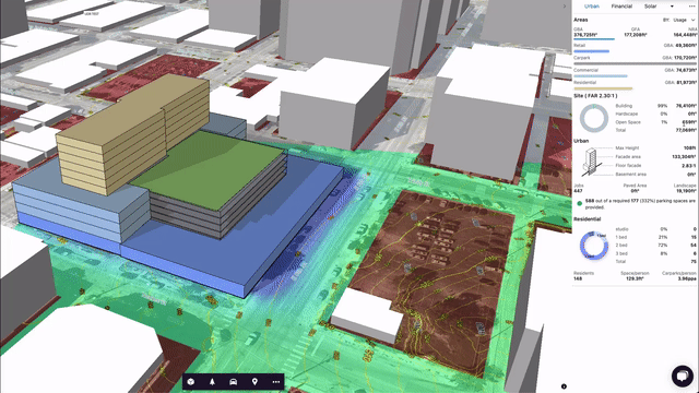
3D Massing
Urban Designers
Consider urban form at any scale.
- Work within the context of the strategic plan
- Draw built form massing and envelopes with easy to use drafting tools
- Customise you planning assumptions and get dynamic feedback as you work on design performance
- Automate repetitive design tasks using generative tools like parking, subdivisions and tree placement
Geospatial Analysis
Assessment Officers
Assess proposals in context.
- Recreate proponents schemes quickly and easily to test impact and change
- Contextualise a proposal in your strategic planning framework
- Import proponents models directly onto the map for assessment purposes
- Track multiple DAs and proposals using our Portfolio function
Digital Twins
Community Engagement
Publish rich digital twins straight to the web.
- Curate a walk-through that tells a story about your city, precinct or development proposal to your stakeholders
- One click to publish your project to a private or public audience
- Embed the result in your website, or create a standalone link
What's in the kit?
3D Drawing tools
Draw land-uses, massings or markups
Customisable Assumptions
Quantify impact, understand performance
Geospatial Analysis
Style, Filter & Join geospatial data sets
ISO27001 Compliant
Government ready information security. View our certificates here.
Stakeholder Engagement
Publish to the web with one click
Extend with Apps
Isochrones, 3D Terrain, SkyView analysis & more
Start creating better cities
Giraffe is free to use for property developers, architects and governments. To access our full set of capabilities, integrate apps and add additional seats learn more about our paid plans.


